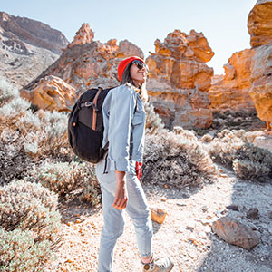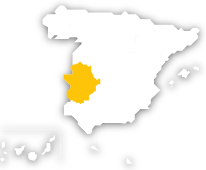
Have you ever travelled on one of Spain’s Greenways? These are trails in natural settings, for use by walkers, cyclists and horse riders, created by repurposing abandoned infrastructure, especially former railway lines. Extremadura has four: Vía Verde Ruta de la Plata, Vía Verde de Monfragüe, Vía Verde de las Vegas del Guadiana, and Vía Verde Mina La Jayona. These greenways make up around 150 kilometres of hiking trails, and are a great way to explore the landscapes of the region.
-
Vía Verde Ruta de la Plata greenway
Located in the north of Cáceres province, this route was formerly the Astorga-Plasencia railway line, and also links to an ancient Roman road. This greenway that connects Casas del Monte and Béjar (in Salamanca province) is about 42 kilometres long. It runs through several small towns and villages in the Ambroz valley: Casas del Monte, Segura de Toro, Gargantilla, Aldeanueva del Camino, Hervás, and Baños de Montemayor. On the route you can also see what remains of the former railway line, such as signal lights, signage, points, etc. One essential stop is the Textile Museum in Béjar, and the town itself is also well worth exploring for its historic and artistic heritage. Hervás is also worth a special mention, with its Protected Landscape, the Castañar Gallego forest. A stroll around the town’s Jewish quarter, one of the best-conserved in Spain, is like a journey into the past. In summer, be sure to go for a swim in one of the lovely natural pools in the area. And if you want to relax, you could visit a spa: the Balneario de El Salugral is on the outskirts of Hervás, and at Baños de Montemayor you can see the remains of the old Roman baths.
-

Vía Verde de Monfragüe greenway
In Cáceres province, this route is one of the entrances to the Monfragüe National Park. In fact, it’s one of three Spanish greenways which are less than five kilometres away from a National Park. It runs for about 20 kilometres, from Las Habazas (Malpartida de Plasencia) to the upper stretch of tarmac trail in Caserío de Urdimalas, following the tracks of a former branch of the Madrid-Valencia de Alcántara railway line.Here you can enjoy rural landscapes with holm oaks and cork oaks, and there’s a good chance of spotting the Spanish imperial eagle, the griffon vulture, the Egyptian vulture, the peregrine falcon, the Eurasian sparrowhawk, and the eagle owl, among other species. You can learn more about this setting at the park’s North Visitor Centre (local road EX 208- Km. 9). You can also walk over wooden walkways and watch livestock grazing freely in the dehesas or pasturelands, and see the abandoned but still interesting Malpartida Station. However, although Monfragüe is all about wild nature, there’s plenty of architectural heritage and history to be seen here too. In Malpartida de Plasencia you can visit the parish church of San Juan Bautista and the country chapels of San Blas, La Virgen de la Luz, San Gregorio, and San Cristóbal that are all grouped together.
-
Vía Verde Vegas del Guadiana greenway
This greenway runs between Villanueva de La Serena and Logrosán, passing through the towns and villages of Don Benito, Rena, Villar de Rena, Torviscal, Palazuelo (Villar de Rena), Madrigalejo, Campo Lugar, and Navalvillar de la Pela. It follows the former railway line between Talavera de la Reina and Villanueva de la Serena.All along its nearly 58 kilometres you can enjoy the beauty of a landscape of pasture, wetlands, and farmland. And if you’re here in winter you’ll be able to see the largest winter habitat of the cranes that migrate here from northern Europe each autumn. In fact, dotted along the greenway there are several Special Protection Areas (SPAs) for birds. Good places to stop and visit include Encomienda Castle and the church of La Asunción in Villanueva de la Serena, and the Logrosán mines (Mina Constanza and visitors’ centre) to discover the local mining heritage.
-

Vía Verde Mina La Jayona greenway
Located to the south of Badajoz province, this greenway follows the former Peñarroya-Fuente del Arco railway line. Over 30 kilometres long, it runs alongside the foothills of the Sierra Morena, through the towns and villages of Fuente del Arco, Valverde de Llerena, Berlanga, and Azuaga. The greenway passes through a landscape grain fields, olive groves, and pastures dotted with holm oaks, some grazed by flocks of merino sheep.Before starting out on the route, we recommend a visit to Mina La Jayona, a former iron mine which was excavated by hand with spades and pickaxes. Today it’s a site of great geological interest, and full of flora and fauna.You can also see Las Quinientas in Berlanga, a conservation park with a huge variety of native trees and plants such as daffodils, orchids, chrysanthemums, fennel, gorse, thyme, etc. The Sierra Norte de Sevilla Natural Park is also very close by.


Travel plans for inspiring you


Book yours
Choose between thousands of activities to live your best life on holiday.